
Read Next
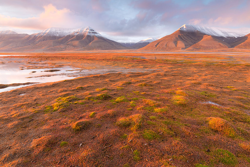
Why You Should Visit Svalbard In Norway For Photography
Svalbard in Norway features untouched...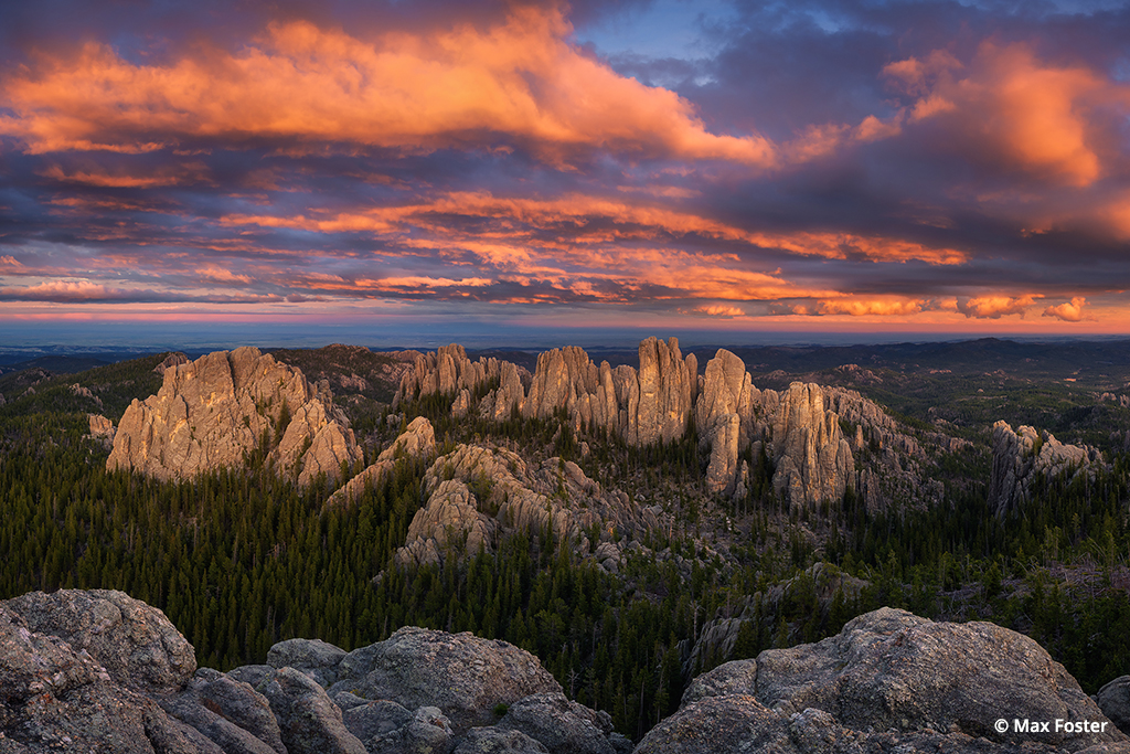
The Needles
The Black Hills of South Dakota cover...
Dinosaur Adventure!
After feeling trapped at home for the...
Intimately Experiencing Ice
Aerial view from an altitude of 1,200 feet of massive icebergs with moulins and meltwater channels in Disko Bay, at the mouth of the Jakobshavn Icefjord, near Ilulissat, Greenland. Photo by Justin Black.
The world is getting smaller. Globalization has brought what once were considered exotic destinations directly into our living rooms. But there are still a few places on the planet that remain truly exotic, all but entirely unexplored. Greenland, the second-largest island on earth, is one of these rare places.
When, Where and How to Visit
A photographic expedition to Greenland is a sailing trip, usually navigating the waters of its western coast where most of the island’s modest population resides in small, colorful villages that aren’t connected by roads. Travel options to the island are fairly limited, including flights from Denmark or voyages from the Canadian Arctic and Iceland. Photographers Frans Lanting and Justin Black led a Visionary Wild photography workshop to Greenland last September, delivering an awe-inspiring opportunity for 18 participants—and for the instructors, as well.
Icebergs at sunset, Disko Bay, Greenland. Photo by Frans Lanting.
“It was possibly the single most rewarding photography expedition I have ever experienced,” says Black. “The coast of Greenland in September is a stunningly beautiful place—a grand landscape of snowcapped coastal mountains, sheer glacier-carved rock faces often thousands of feet high and miles long, vibrant autumn color on the tundra and the vast interior ice cap spilling down to maritime glaciers that calve truly massive icebergs into deep, pristine fjords. In retrospect, I think it may have been the best trip of my life.”
“We chartered a fantastic three-masted schooner,” says Lanting, “for an expedition voyage along the west coast of Greenland. It was a very exclusive photographic experience. Greenland is hardly ever covered photographically. It’s very difficult to get to logistically, and quality photographic experiences are very difficult to come by; you either have to be an accredited scientist, or you end up on a cruise ship with 100 other people, or you have to organize everything yourself.”
Columnar basalt formations, icebergs and the 168-foot expedition vessel Rembrandt van Rijn, at Kuanit, Disko Island, Greenland. Photo by Justin Black.
“One of my key takeaways,” Black says, “is that I can’t believe there isn’t more tourism in Greenland. There’s certainly limited infrastructure, but it’s doable. It’s right between Europe and the U.S., and it’s this incredible place, close to fairly wealthy population centers, and it just boggles my mind that it’s not more on the map. Not that I want it to be crowded!
“We decided to go in September for two reasons,” he adds. “The tundra is in autumn color, and the days are more manageable. September is definitely autumn. The tundra has turned color into hues of crimson, orange and yellow, the frost has killed off the bugs, and day and night are balanced so we have good conditions for Aurora Borealis, but otherwise can get a good night’s sleep because we aren’t trying to shoot ‘magic hour’ light at 2 a.m. Summers in the Arctic can really screw up your internal clock.”
Hanging autumn tundra on a water-streaked granite granite cliff, Qaqullussuit, Uummannaq Fjord, Greenland. Photo by Srdjan Mitrovic.
What to Expect
According to Norwegian legend, warring Vikings, in an effort to deceive their enemies and hide their true location, sent word that they had landed on a new island that was cold and icy, while another nearby island was habitable and green. In this way, the lush island became Iceland and the ice-covered island became Greenland. It should be no surprise that a photographic expedition to Greenland is shaped by ice.
“It’s all about experiencing ice,” Lanting says, “the dynamic nature of ice, because, you know, Greenland is melting. And the landscapes are mind-blowing. When you’re there and you experience ice firsthand in a way that becomes very visceral, it’s very aesthetic. It’s also an opportunity to be surrounded by ice in a way that’s impossible anyplace else in the Northern Hemisphere. There isn’t ice of that scale accessible anywhere in Alaska. And you don’t have the same grandiose landscapes in the Canadian Arctic, either.
On an excursion vessel out of Ilulissat Harbor, expedition participants photograph an iceberg formed of ancient glacial blue ice, Disko Bay, western Greenland. Photo by Dan Warbrick.
“In the High Arctic,” he continues, “people who live there have dozens of different words to characterize the different kinds of snow and ice they deal with on a daily basis. That may seem like an abstraction when you hear about it, but when you’re there, you really start to appreciate the different characteristics of ice, and that provides an endless array of opportunities to translate it into images—from gigantic icebergs, to little pieces of brittle ice, to ice jewels that are totally transparent. We bring ice onboard with us, and we continue to photograph ice even as we’re sailing along.
“If you’re on a cruise ship,” Lanting adds, “you don’t experience ice in the same way, because you’re above it and removed from it. On the schooner, we’re able to improvise. And we can make decisions that are truly expeditionary in style. That enabled us to drop anchor in places and go on shore in spots where we know for a fact no photographer had ever been before. And that’s a big thing to be able to say.”
Stormy seas and icebergs in the Vaigat Strait, Greenland. Photo by Barbara Wrubel.
Once on shore, photographic opportunities still include ice, but also the inhabitants of the island—both human and otherwise.
“We go into villages and learn firsthand how people live there,” Lanting says, “which is fascinating in its own right—just 55,000 people on the second-largest island on the planet. And these people are going, in two generations, from practicing a Neolithic lifestyle of hunting and gathering to living in modern homes with Internet access. It’s really a mind-bending experience, and it leads to all kinds of interesting photographic opportunities. There are musk oxen there, there are animals of all kinds. Now, this is not primarily a wildlife photography experience—we’re on an expeditionary voyage, so it’s primarily about the landscape. And it’s about ice. Ice and people.”
Photographer taking pictures of tundra landscape, Uummannaq Fjord, Qeqertanguaq Bay, Greenland. Photo by Frans Lanting.
“One of the things that’s a shame about Greenland,” Black adds, “is that it could be, and should be, a major destination for arctic wildlife. They could have massive walrus and seal colonies, massive seabird colonies, and all of that sort of thing. But the downside of Greenlandic culture is that they’re traditionally hunters, and even though these days they live in villages with well-stocked supermarkets, when a couple of guys go out to catch some salmon or halibut, they’ve got a rifle in the boat. And if a seal pops its head up within range, it’s gone. They’re pretty brutal on the wildlife.”
These days, Greenland’s ice is melting. Land has been exposed for the first time in centuries, and glaciers are receding at an alarming rate. The melting process leads a vicious cycle, speeding the destruction of the glacier as it calves mountainous icebergs into the sea.
“The rate of flow of icebergs from the fjords we visit is just tremendous,” Black explains. “When you get warmer water coming into the fjords, that causes the glaciers to calve more quickly. And the glaciers have basically been holding back the ice behind them so, as they calve more quickly, more ice can flow down off of the ice cap to calve off the face of the glacier into the sea. And that process is accelerated because warmer temperatures during the summertime cause more melting on the surface, which then creates these lakes on the surface, which eventually melt through and flow to the bottom, which lubricates the glacier and so it moves faster. Plus, you just have meltwater that’s flowing from the ice sheet down to the coast and out to sea. And then, during the winter, it all freezes again, and it’s basically all covered with snow down to the water.”
“Greenland is of enormous importance to all of us because of climate change,” Lanting says. “Greenland is melting. And the very process of melting ice is spectacular beyond words when you’re in the midst of it. You really feel like you’re part of a historical event of epic proportions. There’s more ice coming off Greenland than any other place in the Arctic. And there’s one place, in particular, that’s responsible for a very significant percentage of all the icebergs that end up in the North Atlantic—the Jakobshavn Glacier. Most likely, the iceberg that was hit by the Titanic came from that glacier. The repercussions for what’s happening in Greenland for our lives and the lives of anyone who lives in a coastal area, it cannot be overstated. Now, of course, as the ice melts, it also means that landscapes are becoming visible for the first time in perhaps 100,000 years or more. So that creates a Pleistocene-like situation that’s really interesting in its own right. The last Ice Age is being re-created along the coastline of Greenland.”
For more information about this year’s upcoming Greenland expedition with Visionary Wild, visit visionarywild.com/workshops/greenland2016.